It is sometimes helpful to store extra non-graphic information in landscape plans. For example, it might be advantageous to store behind a furniture symbol the details of size, cost, manufacturer, and material used in construction. Similarly, users might sometimes require GPS, Google Earth, and photographic information about species symbols. CAD drawings containing this extra information become much more than a simple replacement for a drawing board. They can become a living document that evolves as the garden or larger landscape develops.
![]() Here is a link to a small movie that overviews managing non-graphic information in landscape drawings. We focus on using the extended data tool.
Here is a link to a small movie that overviews managing non-graphic information in landscape drawings. We focus on using the extended data tool.
Tip: Extended information can be stored behind any entity – lines, arcs, blocks, etc.- all candidates for stored information. There is one rider; however, if you want to use the gCADPlus tool to propagate extended data across many instances of the same symbol, the symbol must be created as a block.
Tip: You might consider supplying your clients with a CAD design file and encouraging them to download and use the demonstration version of gCADPlus to view the extra non-graphic information you’ve added.
An example
Although it is not apparent, the design shown below contains a considerable amount of extended information. Details of outdoor furniture, seating, paving, and irrigation design are all there, but only appear when required.

Using extended data tools
Types of extended data stored in gCADPlus drawing files are listed below.
Furniture data
For example, you may have specified outdoor furniture from a particular manufacturer in the design. It would be helpful to store the manufacturer’s name, type, and cost of the furniture shown. The figure below shows some information about a cast iron fire pit in a gCADPlus drawing with extended entity information about that furniture set. This information is not printed, but can be displayed on cue or extracted to an Excel file.

Paving
A design may well call for an area of paving outlined by a polyline. The STOREDATA feature is used here to store information about the supplier, paver size/type, cost/paver, etc.
Decking
The feature might well be used to store information and a quote about a quotation for a custom build of some decking/seating around the base of a tree.
Irrigation
The length type and supplier of irrigation equipment can be stored.
Grass
The total area to be grassed, the type of turf, and the company contracted to lay the grass is often stored.
Lighting
Important information about lighting data can also be stored.
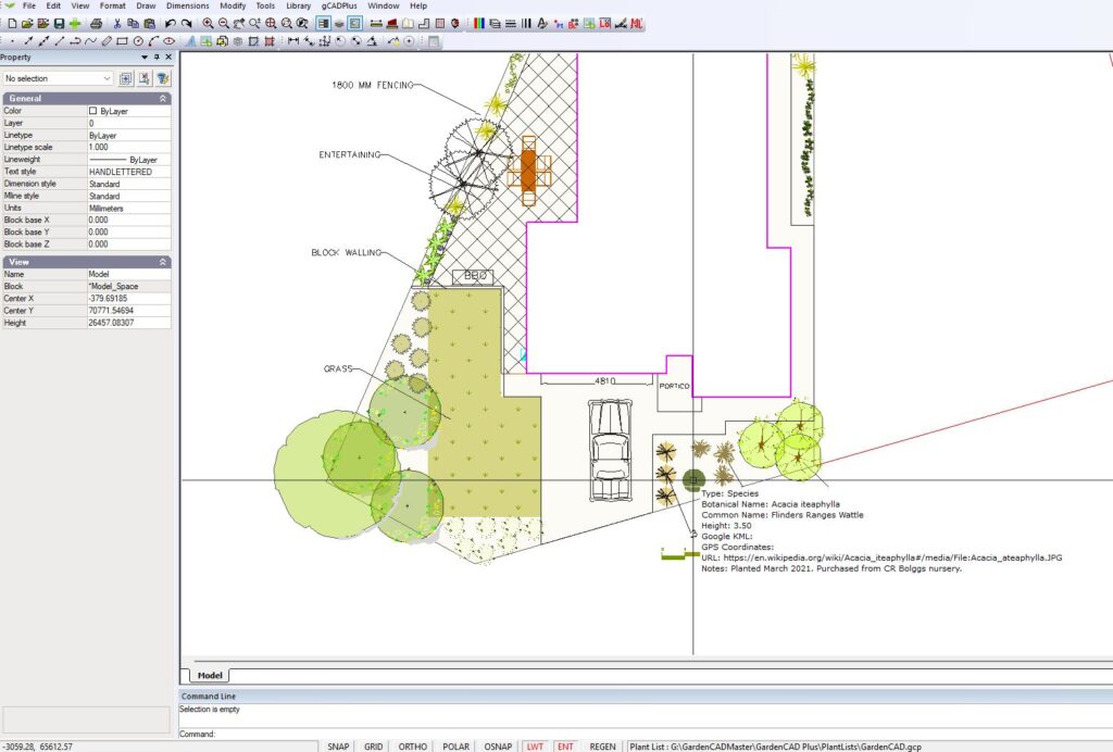
Species
The species option of the extended data tool allows for storing considerable extended information about particular plants. Although not used in the example below, if gCADPlus were being used in (say) botanical gardens or arboretums, information on Google Earth location and GPS data can be recorded along with species information in the extended data dialogue box.
Google Earth
The species data dialogue box also allows the storage of KLM file information. This feature may be helpful for staff managing botanical gardens, arboretums and other large sites.
Link to URL
gCADPlus can store a URL and a link to an external location as part of extended entity data. In the example shown, if a user clicks on the link to the URL button in the species dialogue box, they will be taken to an online database where information on propagation methods for the plant is stored.
Tip: To display the information in real time, press the EXT tab. When your mouse hovers over the entity, much of the stored data becomes visible. It works just like a tooltip.
Tools to manage extended data
![]() This movie shows that storing non-graphic information in landscape drawings is possible. That data can be attached to entities and blocks and allows the display of information about decking, paving, furniture, and species. We show how to edit the information, turn off the display of extra data and extract information to spreadsheet format.
This movie shows that storing non-graphic information in landscape drawings is possible. That data can be attached to entities and blocks and allows the display of information about decking, paving, furniture, and species. We show how to edit the information, turn off the display of extra data and extract information to spreadsheet format.
Highlight extended data
This option can highlight those entities in a design with extended data associated with them in magenta colour. If entities such as the circle outlining the canopy of a specimen of the Grey Alder (shown below) contain extended data,
Extract stored data
This option writes all extended entity information in a drawing to a CSV data file ready for spreadsheet analysis.
Propagate stored data
Use this option to update a block symbol with extended data. For example, if the same symbol had been used to indicate many instances of the same plant species in an arboretum, then this tool could be used to update all block instances to carry that same extended entity data.
Movies showing the use of extended data
![]() Managing extended data in landscape drawings with gCADPlus. We store non-visual data with surface treatments, seating, links to photos of species, etc., in the drawing file.
Managing extended data in landscape drawings with gCADPlus. We store non-visual data with surface treatments, seating, links to photos of species, etc., in the drawing file.
![]() This movie attempts to answer this question from a potential user: “Firstly, I want to be able to design my garden, then I want to make it a living document where I can record the plants as I plant them and record information about them such as date of planting, where I bought them from, etc.”
This movie attempts to answer this question from a potential user: “Firstly, I want to be able to design my garden, then I want to make it a living document where I can record the plants as I plant them and record information about them such as date of planting, where I bought them from, etc.”
![]() This movie shows how the extended data feature in gCADPlus can be used to store and extract information about irrigation equipment in a design for a large-scale domestic setting.
This movie shows how the extended data feature in gCADPlus can be used to store and extract information about irrigation equipment in a design for a large-scale domestic setting.